What this is: the hunt puts a case file in your hands. This is what's in it. Surveyors, engravers, naval officers and, later, aircraft with survey cameras have been measuring this inlet for four hundred years. Read them in order and you can watch the water move, the village appear, and one man's name get engraved onto a channel and stay there.
Every image below is a photograph of an actual sheet, not an illustration. The six map exhibits link straight to the Library of Congress record they came from.
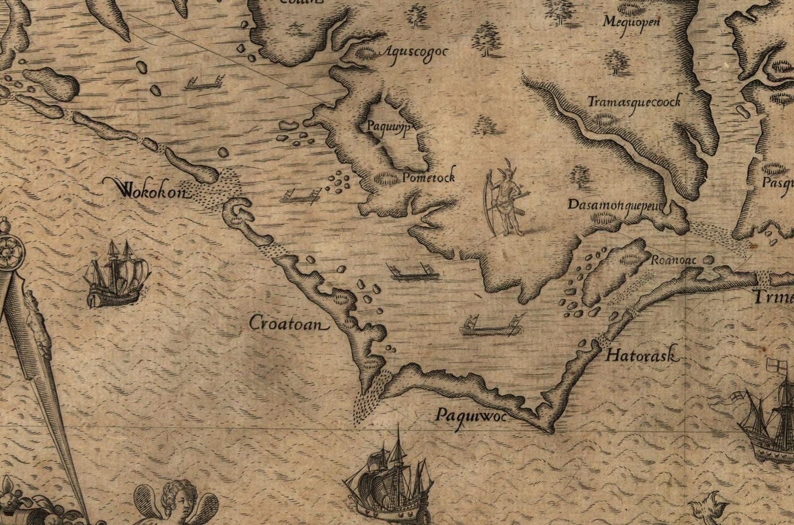
Exhibit A — 1590. Before anyone called it Ocracoke.
Theodor de Bry engraved this after John White's survey of the Carolina banks and published it at Frankfurt in 1590, alongside Thomas Hariot's report on the Roanoke voyages. The island is lettered Wokokon — the spelling the Roanoke voyagers used, and the name historians generally read as Ocracoke. Croatoan lies down the chain from it, then Hatorask. North is to the right on this sheet, which throws most people the first time.
This is the island one hundred and twenty-eight years before Blackbeard died on it.
1733: the first time his name hits a chart
Edward Moseley's A New and Correct Map of the Province of North Carolina came out in 1733 with an inset plan of Ocracoke Inlet — depths, shoals, and sailing directions for masters trying to get over the bar. On that inset an anchorage is lettered "Thatches Hole."
Thatch was a common contemporary spelling of Teach. Fifteen years after the beheading, a surveyor working for the colony put the pirate's name on an official chart of the inlet and it never came off. Later mapmakers copied it forward, respelled it, and we still use it.
Thatches Hole, 1733. Teachs Hole, 1808. Teach's Hole today. Same water, same man, three hundred years of cartographers agreeing with each other.
Exhibit B — 1770. Seventeen feet in the channel.
Captain John Collet, governor of Fort Johnston, surveyed the province and had this engraved in London in 1770. Ocracoke is "Occacock I.", the gap beside it "Occacock Inl." Beacon Island sits in the middle of the inlet. To the southwest, in red, is Portsmouth — a town the colonial assembly laid out in 1753 for one purpose: to lighter cargo off deep-draft ships that couldn't clear the bar.
Read the numbers and you can see the problem. Seventeen feet at the mouth. Nine over the shoals. Everything bound for New Bern, Bath and Edenton had to be broken down and carried across that.
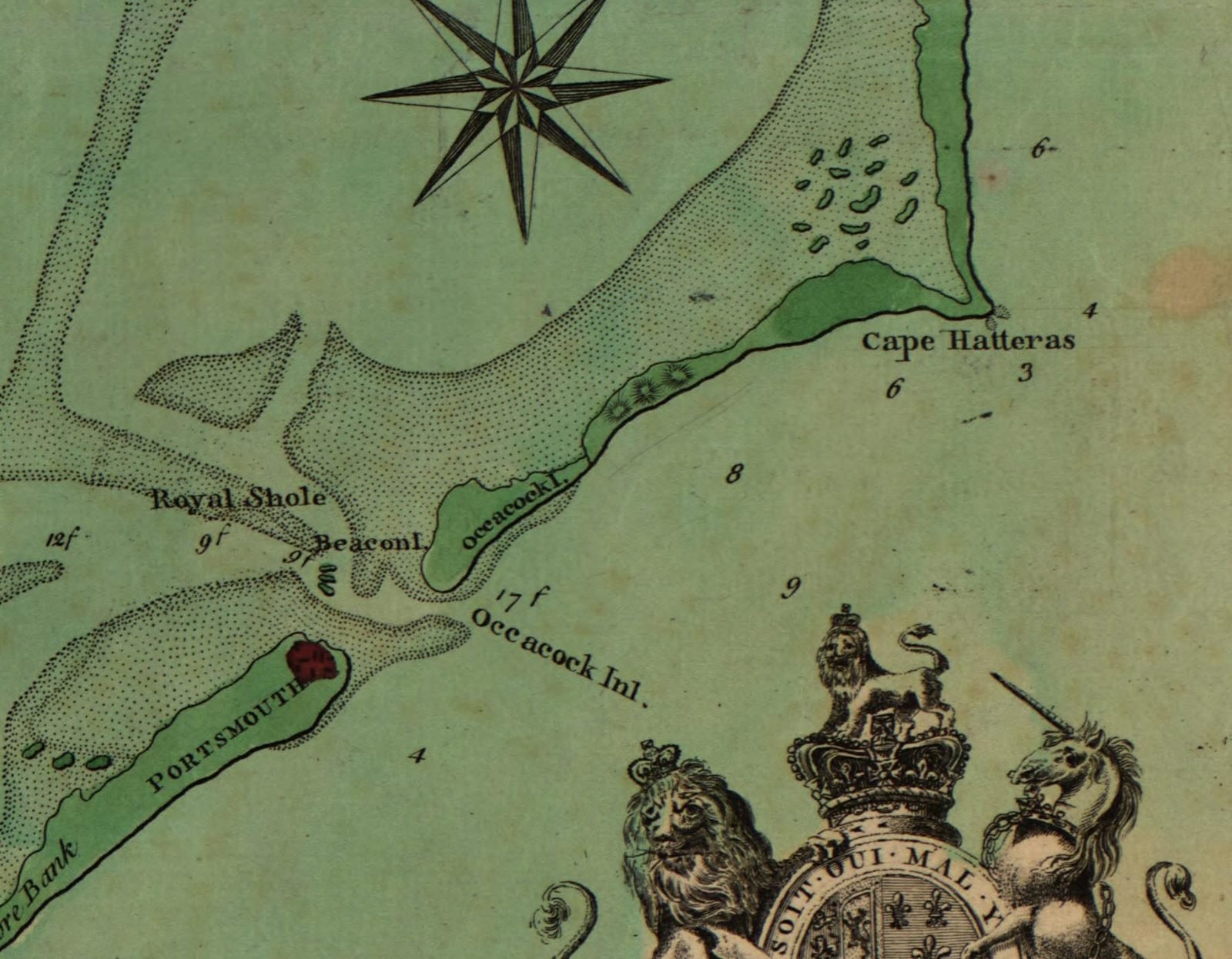
Exhibit C — 1775. The front door to a colony.
Henry Mouzon's map, published in London the year the Revolution started, is the most detailed picture of this inlet anyone had yet printed. "Occacoke Inlet" in big letters; a marked "9 Feet Beacon" off Beacon Island; soundings threaded all the way through the bar; and out to the east, a dotted line labeled "a Good Channel."
Note the spelling of the sound: PAMTICOE. Nobody had settled on how to write any of these names yet. Ocracoke alone gets spelled Wokokon, Ocacock, Occacock, Occacoke, Ocrakoke and Ocracoke across the documents on this page.
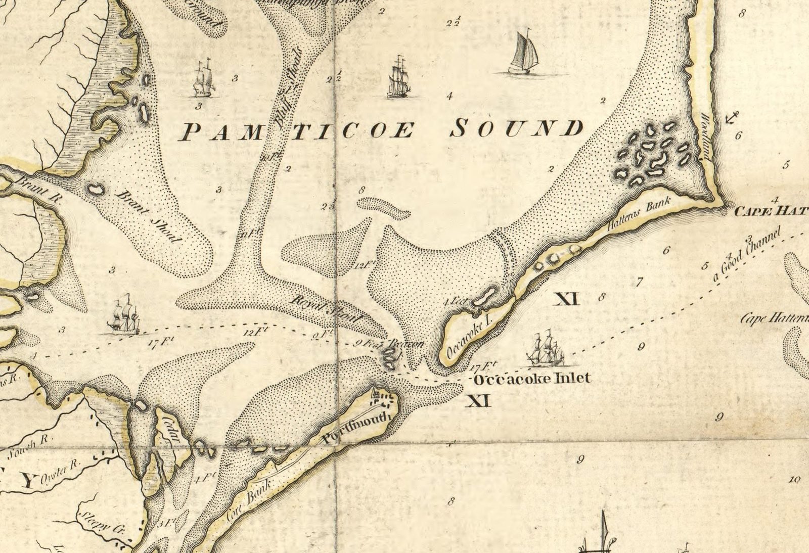
Exhibit D — 1808. Teachs Hole, in print, and a town of pilots.
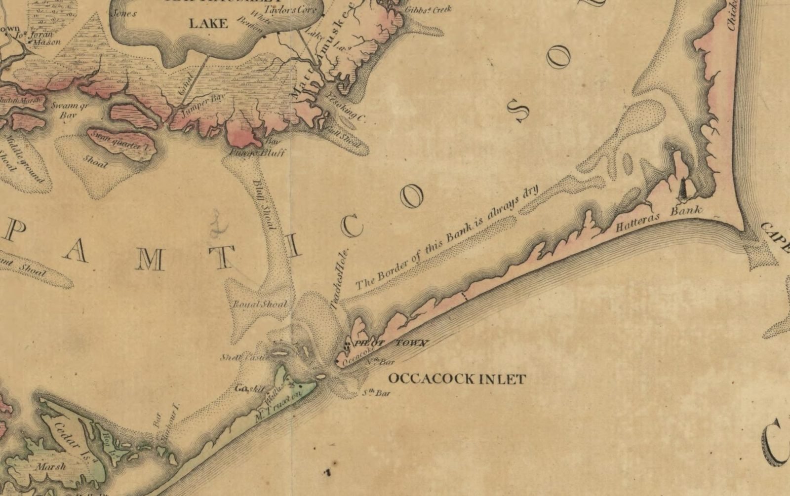
This is the one to look hard at. Jonathan Price and John Strother's first actual survey of the state, engraved in Philadelphia in 1808, letters "Teachs Hole." along the channel behind the island — and across Ocracoke itself, in spaced capitals, PILOT TOWN.
That was the village's working name. The colony licensed branch pilots to bring ships over the Ocracoke bar and set aside land on the island for them; the settlement that grew up around Cockle Creek was known as Pilot Town, and when Price surveyed the place in 1795 he recorded that the inhabitants were pilots, about thirty families of them.
West across the inlet, the word Shell Castle. John Gray Blount and John Wallace started building on a shell-and-oyster rock there in 1789 — warehouses, a wharf, a store, a tavern, a windmill, a whole lightering business on a bar in the middle of nowhere. Their lighthouse, finished by 1798, was the first on the Outer Banks. Lightning destroyed it in August 1818. The island itself is gone.
Price had already given the inlet its own dedicated chart. His 1795 Occacock from Actual Survey, engraved by a New Bern silversmith and printed at New Bern, is described by the State Archives of North Carolina as the first map drawn, engraved and printed in the state. It names Teaches Hole too.
Exhibit E — 1861. Measured to the foot, and already finished.
The U.S. Coast Survey put men on this inlet in 1857 and worked the Pamlico Sound hydrography through 1858; the sheet says so in its own note. What came out is the first Ocracoke that a modern eye reads as a real chart — Wallace's Channel, Beacon Island with a light on it, Portsmouth, breakers, and soundings scattered like buckshot across every foot of water.
And it was already too late. A hurricane in September 1846 had cut two new inlets through the banks to the north, at Hatteras and at Oregon. Over the following fifteen to twenty years the shipping went with them. Ocracoke Inlet had been the coast's front door for two centuries. It stopped being one inside a generation.
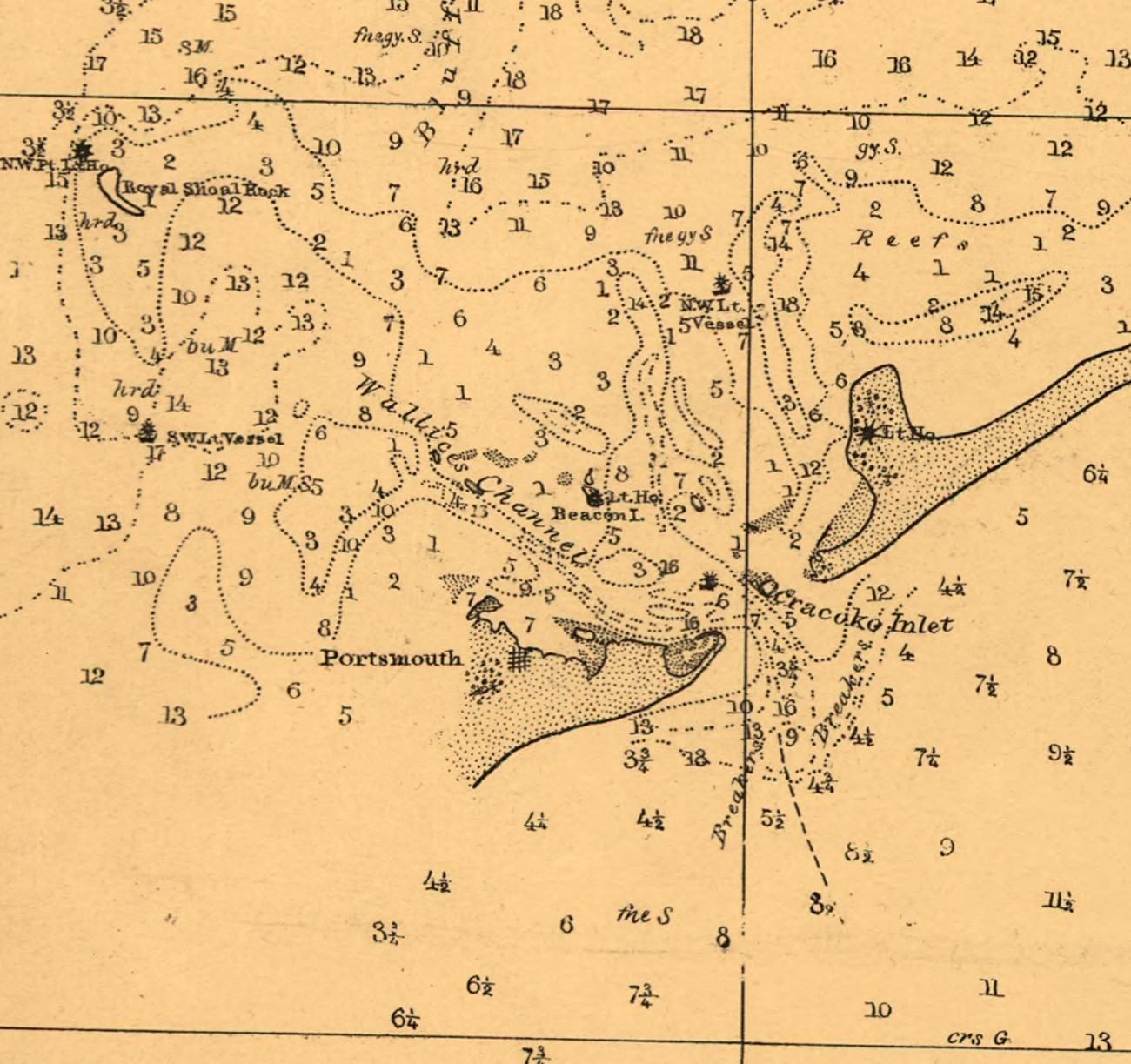
Exhibit F — 1862. A fort in the inlet.
L. Prang & Co. of Boston printed this for a public following Burnside's expedition, and it is the sheet that names the war. "Ocrakoke Inlet" — with a k — and immediately beside it, FT. MORGAN.
That was the Confederate earthwork on Beacon Island, more often called Fort Ocracoke. Volunteers began it on 20 May 1861. When Union forces took Forts Hatteras and Clark up the banks that August, its garrison abandoned it and burned what they could; a Union landing party finished the job in September and found the place deserted. Beacon Island itself has since eroded away.
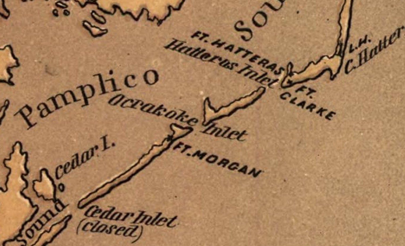
Exhibit G — 1927. The village, before the road.
A survey of Ocracoke village from the National Park Service's Cape Hatteras collection. Silver Lake is already named — islanders had been calling the tidal pond that for years, whatever the charts said about Cockle Creek. The Ocracoke Lt. Ho. is marked, and the Pamlico Inn Dock, and a fish house, and two Methodist churches, north and south, in a village of a few hundred people.
What isn't marked: a single paved road. Getting to Hatteras meant thirteen miles of sand track and a ferry, and one islander described the trip to Manteo as "like going on a safari across a desert."
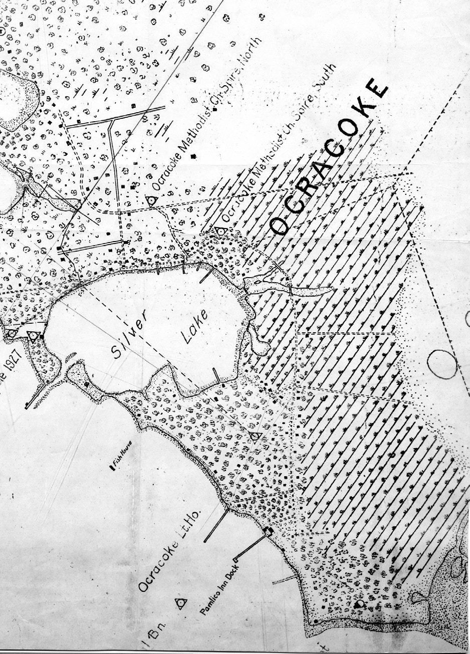
Exhibit H — 1936. The whole village from the air.
This is the one to sit with. The lighthouse stands white and unmistakable in the middle of the frame. The harbor behind it is a broad shallow bowl with a narrow neck to the sound — the Army Corps of Engineers had dredged Cockle Creek into a working harbor only five years earlier, in 1931, and the Navy hadn't yet come to deepen it again for the war.
Two long piers run out into Pamlico Sound, because that is how you arrived. Everything else is sand tracks, live oak and yaupon, and a few hundred houses. Six years after this photograph, the Navy commissioned a section base here, poured the island's first concrete road, and dredged the harbor deep enough for patrol craft. Compare it to the village you'll walk today.
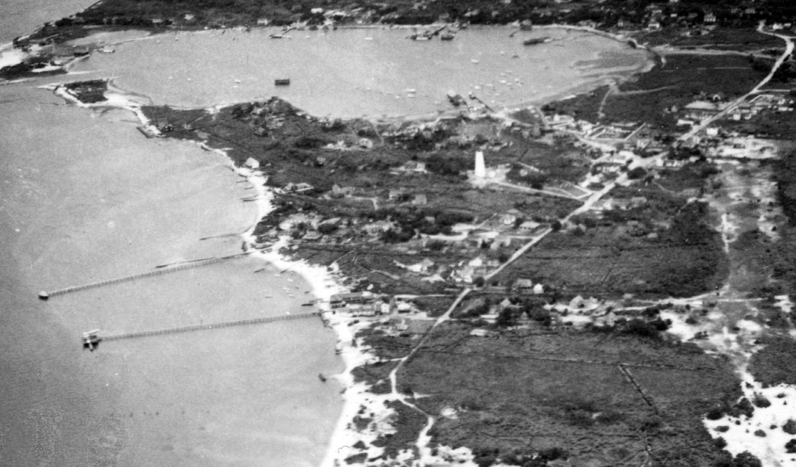
Exhibit I — 1966. Straight down on the light.
The Ocracoke Light Station from overhead: the 1823 tower, the double keepers' quarters under the live oaks, the boardwalk, and — the detail the Park Service bothered to note in its own caption — a garage and a chicken house that are no longer there.
The tower was built in 1823 by Noah Porter of Massachusetts and lit by 1824. It is the oldest lighthouse still in operation in North Carolina, and one of the oldest still working anywhere in the country. It has nothing whatsoever to do with Blackbeard, who had been dead a hundred and five years when it was built, and it gets folded into his story constantly.
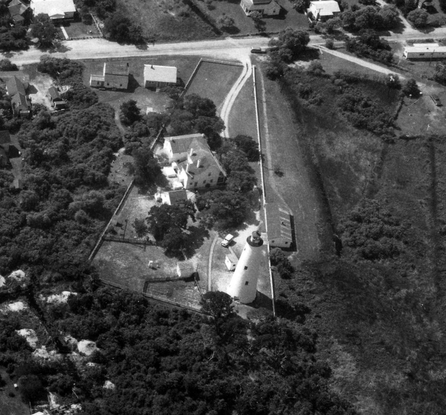
Exhibit J — 1993. The village in black and white.
Jump twenty-seven years. This frame comes from North Carolina's 1993 digital orthophoto quarter-quadrangle series — a straight-down, geometrically corrected aerial of the kind surveyors now use instead of a chain and a rod.
Silver Lake has its two breakwaters. NC 12 runs in from the top right past the ferry terminal. The wooded lobe at bottom left, running out to the sound, is Springer's Point — called Teach's Plantation by local tradition, though no deed is known to carry the name, and the ground you walk to look out over Teach's Hole. Fix this frame in your head; you'll see it again at the bottom of the page.
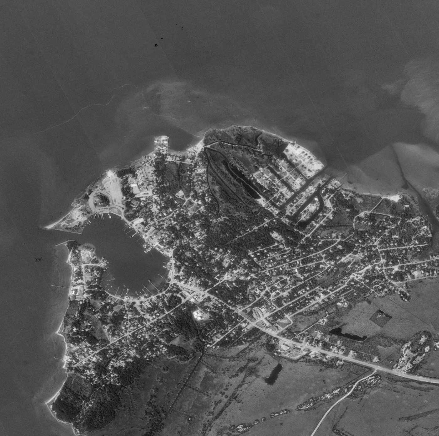
Exhibit K — 2011. What the soundings were about.
NOAA flew the Outer Banks on 28 August 2011, the day after Hurricane Irene came ashore at Cape Lookout. This frame is the south end of Ocracoke Island and the mouth of the inlet, and it is the single most useful picture on this page for understanding every chart above it.
All that pale water is not water. It is sand — the ebb-tide delta of Ocracoke Inlet, shoals fanning out into the Atlantic, shifting with every storm. That is what Collet's "9 f" and Mouzon's "9 Feet Beacon" were warning about. That is why a town called Portsmouth existed, and why men made a living piloting other men's ships across a quarter mile of moving ground. It is also, incidentally, exactly the kind of shallow water a shallow-draft sloop could work and a Royal Navy warship could not — which is why Maynard came for Blackbeard in two small hired boats.
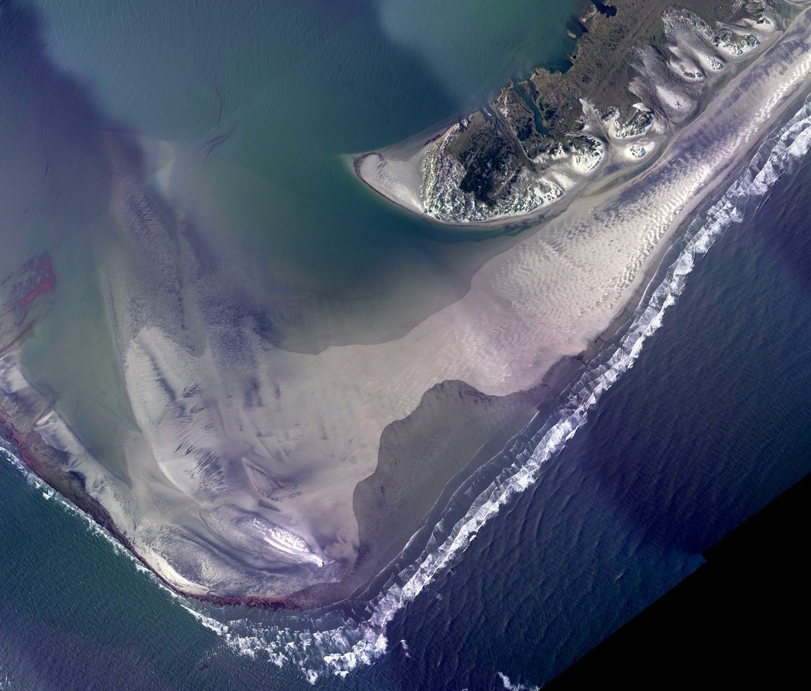
Exhibit L — 2019. The morning after Dorian.
On the morning of 6 September 2019 the eye of Hurricane Dorian passed the coast and pushed the sound back over the island. The National Weather Service recorded a four-to-seven-foot storm surge on Ocracoke. People were pulled out of their attics by boat. Others were airlifted to the mainland. NC 12 was torn up.
NOAA's survey aircraft flew the island the next day, and this is what it saw: the ferry staging lot packed, the harbor full of boats that rode it out, and a village that has been doing this since before anyone thought to write the name down.
The full storm record is here — every hurricane that has left a mark on this island since 1846, and what closed and never reopened. Three hundred years of maps on this page, and the one constant is that the water decides. Blackbeard picked this inlet because it was shallow, tricky and hard to follow a man into. The same qualities are why the island still gets its feet wet.
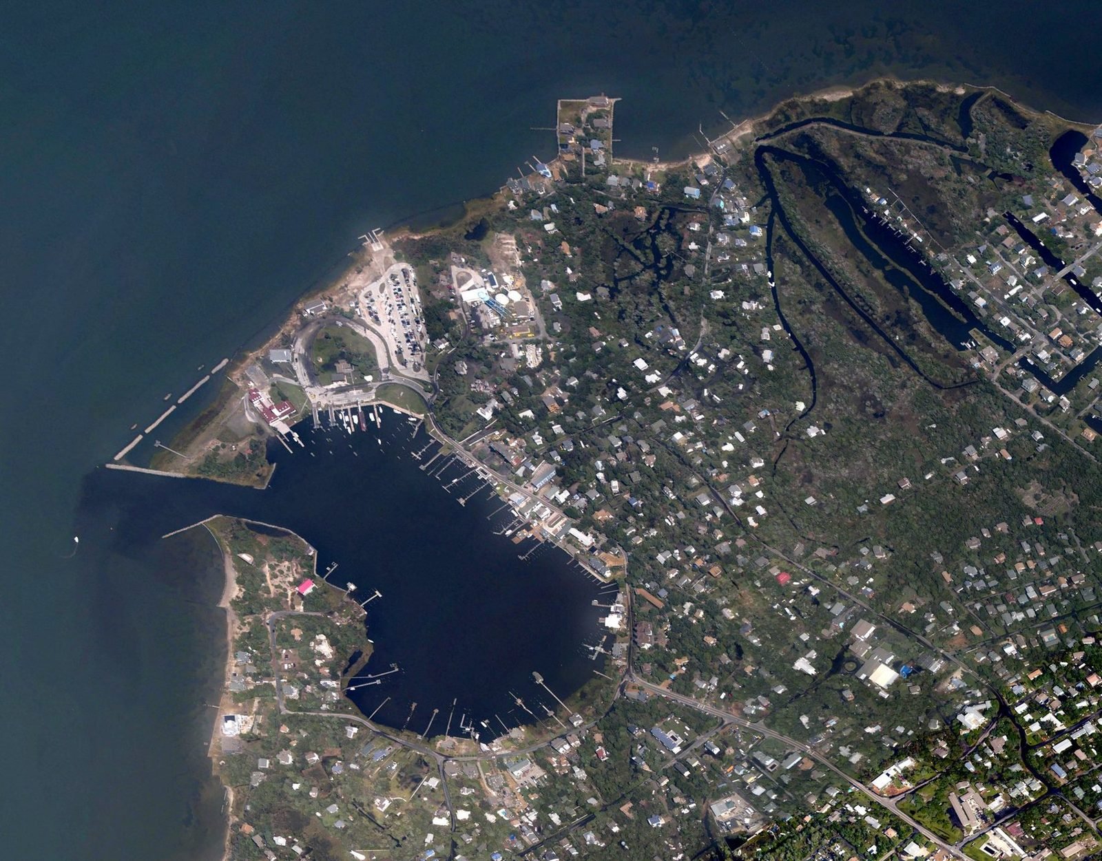
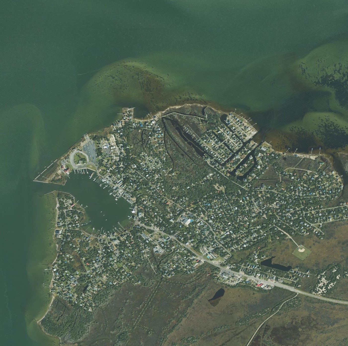
Exhibit M — today. The same frame, three decades on.
Current federal orthoimagery of the village — the National Agriculture Imagery Program's most recent North Carolina coverage. This is the same frame as Exhibit J, corner for corner. Scroll up, flip between the two, and you can read three decades off the ground: the east side filled in, the docks rebuilt, the tree canopy thickened, the shoreline holding roughly where it was.
Then set it against Exhibit H, the 1936 aerial, and count what a single lifetime did to a sand island that had looked more or less the same since Price surveyed it.
What the file proves
- The name is real and it is old. Not a tourist invention, not a gift-shop flourish. Thatches Hole in 1733, Teachs Hole in 1808, Teach's Hole on the chart today — a piece of water named after a man who was killed in it, by people who remembered.
- This inlet mattered more than the island did. For two hundred years everything North Carolina bought or sold came over that bar. Portsmouth existed to lighter it. Shell Castle existed to warehouse it. Pilot Town existed to steer it. All three are gone or going.
- The ground moves. Beacon Island eroded out from under a fort. Cedar Inlet closed. Cockle Creek became a harbor. Ocracoke Inlet is the only inlet on this coast that has stayed open through more than four hundred years of recorded history, and even it has crawled.
- And the water still runs the place. Look at 1936 and then at 2019 and the technology is the only thing that changed. The sound came over the island in Dorian the way it has always come over the island. Everyone who ever drew this inlet was drawing something temporary.
What the file doesn't prove
Four centuries of surveyors measured this inlet to the foot. Naval officers charted every shoal. Aircraft photographed the village in 1936, in 1966, and after two hurricanes. Not one of them drew an X.
There is no treasure on any of these sheets, because there is no treasure — not that anyone has produced. The full accounting is here: what was recovered from his flagship, what never was, and the open question of whether a chest was ever buried at all.
Take the file to the ground
Reading it is one thing. Blackbeard's Gold: The Crossing hands you a case file on the ferry and turns you loose on the village and the water these sheets describe — including, if you'll walk for it, the sound-front beach at Springer's Point looking straight out over Teach's Hole.
Start the Hunt — $29 per team Pick your crossing$29 per team of up to six, not per person. Your team link arrives by email straight after checkout. Nothing to install.
Questions about the file
- Are these real historic maps of Ocracoke?
- Yes. Every exhibit is a photograph of an actual sheet or a real survey frame. Six maps come from the Geography and Map Division of the Library of Congress. Three older aerials and surveys come from the Cape Hatteras National Seashore collection by way of the Park Service's 2016 cultural landscape report. The four modern aerials are government orthoimagery: two NOAA emergency response flights after hurricanes, a 1993 orthophoto, and current USDA coverage. Nothing on this page is an artist's impression, and we've said so where we couldn't get an image we were entitled to publish.
- What is the oldest map that names Blackbeard at Ocracoke?
- Edward Moseley's 1733 map of the province, which carries an inset plan of the inlet with an anchorage lettered "Thatches Hole" — fifteen years after he was killed there.
- Where is Teach's Hole on a modern map?
- It's the channel and anchorage off the southwest side of Ocracoke Island, inside the inlet. Walk out to the sound-front beach at Springer's Point Preserve at the south end of the village and you are looking at it. Free, foot access only, 8am to sunset, closed Mondays. There is no marker on the water — there's nothing to mark.
- Can I download and reuse these images?
- The six Library of Congress maps are public domain, with no known restrictions on use. The Park Service, NOAA and USDA images are federal records. Each map exhibit links back to the holding institution — go to the original rather than to our copy, and you'll get far better resolution than we can serve. The two NOAA storm frames have had brightness and contrast adjusted so you can see anything at all; the raw files are almost black.
- Do I need any of this to play the hunt?
- No. The hunt stands on its own and explains itself as you go. This page is here because people keep asking whether the case file is a gimmick. It isn't — this is the archive it's built out of.
Sources
Exhibits A–F: Library of Congress, Geography and Map Division — de Bry 1590 (item 78694920), Collet 1770 (83693769), Mouzon 1775 (74692513), Price & Strother 1808 (2011593508), U.S. Coast Survey 1861 (99447456), L. Prang & Co. 1862 (99447454). Exhibits G–I: NPS / Cape Hatteras National Seashore Collection, reproduced in Susan Hitchcock, Cultural Landscape Report: Ocracoke Light Station, National Park Service, 2016. "Thatches Hole" on the 1733 Moseley map: Index to the Moseley Map of North Carolina, 1733, and the NPS Historic Resource Study for Cape Hatteras National Seashore; the inset is described in H. G. Jones, "Shaping North Carolina, 1500–1775," UNC Libraries. Portsmouth 1753 and the town's purpose: National Park Service, Cape Lookout National Seashore. Shell Castle, Blount and Wallace, and the 1798 lighthouse: NCpedia and the NPS Historic Resource Study. Pilot Town and the branch pilots: NPS Cultural Landscape Report and Historic Resource Study. Price's 1795 chart as the first map drawn, engraved and printed in North Carolina: State Archives of North Carolina. The September 1846 hurricane and the shift to Hatteras Inlet: NC Department of Natural and Cultural Resources and USGS Professional Paper 1177-B. Ocracoke Inlet's continuous history: NCpedia. Fort Ocracoke / Fort Morgan on Beacon Island: NPS Historic Resource Study and UNC Documenting the American South. The 1931 Army Corps dredging of Cockle Creek, the wartime Naval Section Base and the island's first concrete road: NPS Cultural Landscape Report and the Ocracoke Historic District National Register nomination. Ocracoke Lighthouse, Noah Porter and 1823: National Park Service and NC Department of Natural and Cultural Resources. Exhibit J: 1993 digital orthophoto quarter-quadrangle, USGS / North Carolina orthophoto program, served by NC OneMap. Exhibits K and L: NOAA National Geodetic Survey emergency response imagery, flights of 28 August 2011 (Hurricane Irene) and 7 September 2019 (Hurricane Dorian). Hurricane Irene's landfall at Cape Lookout on 27 August 2011 and Hurricane Dorian's 4-to-7-foot surge on Ocracoke on the morning of 6 September 2019, including the attic rescues and airlifts: National Weather Service, Newport / Morehead City. Exhibit M: USDA National Agriculture Imagery Program, current North Carolina coverage via the USGS National Map, retrieved August 2026.