The short version: Ocracoke's problem is not wind. It's a village three to seven feet above sea level, on the back side of a sandbar, reachable only by boat, on one road that fails before anything else does. A hurricane doesn't have to hit Ocracoke to close it. In August 2025 a storm that stayed two hundred miles offshore emptied the island for a week.
Last checked and updated 4 September 2026. Storm-by-storm figures below are from the National Weather Service, the National Hurricane Center, the National Park Service and USGS unless attributed otherwise.
Why Ocracoke floods backwards
Most people picture a barrier island being overrun from the beach. That happens here, and it closes the road. But the flooding that puts water through the village comes the other way — out of Pamlico Sound, from the west.
The National Weather Service has a name for it: the slosh effect. As a storm comes up the coast, its easterly winds push the whole shallow body of Pamlico Sound to the west, piling it against the mainland — which is why Oriental and Bayboro flood first. Then the center passes, the wind swings hard to the west or northwest, and all that piled-up water comes back across. The Weather Service is specific about the timing: sound-side flooding usually arrives one to two hours after the wind shift.
An Ocracoke villager, quoted in a National Park Service report, says it better than any agency ever has:
"When it gets by Cape Hatteras the wind will shift back to the northwest and here will come all this water out of the sound — and the inlet won't take care of it as fast as it should."
This is not folklore. A 2023 USGS study of the barrier islands during Dorian found the transformation was "primarily driven by inundation of the island from Pamlico Sound" — sound water running back seaward carved more than eighty channels out through the dunes to the beach and stripped roughly eighteen percent of one island's volume. USGS notes that this sound-side mechanism is understudied compared with ocean-side erosion.
The practical consequence: the storms that hurt Ocracoke are the ones whose centers pass west or just northeast of it, so the wind swings behind them — Dorian, Alex, Matthew, Gloria. Storms that land far down the coast leave Ocracoke on the weak side, and the rotation can actually prevent the sound-side surge entirely. That is exactly what happened with Florence in 2018, a monster of a storm that barely wet the village.
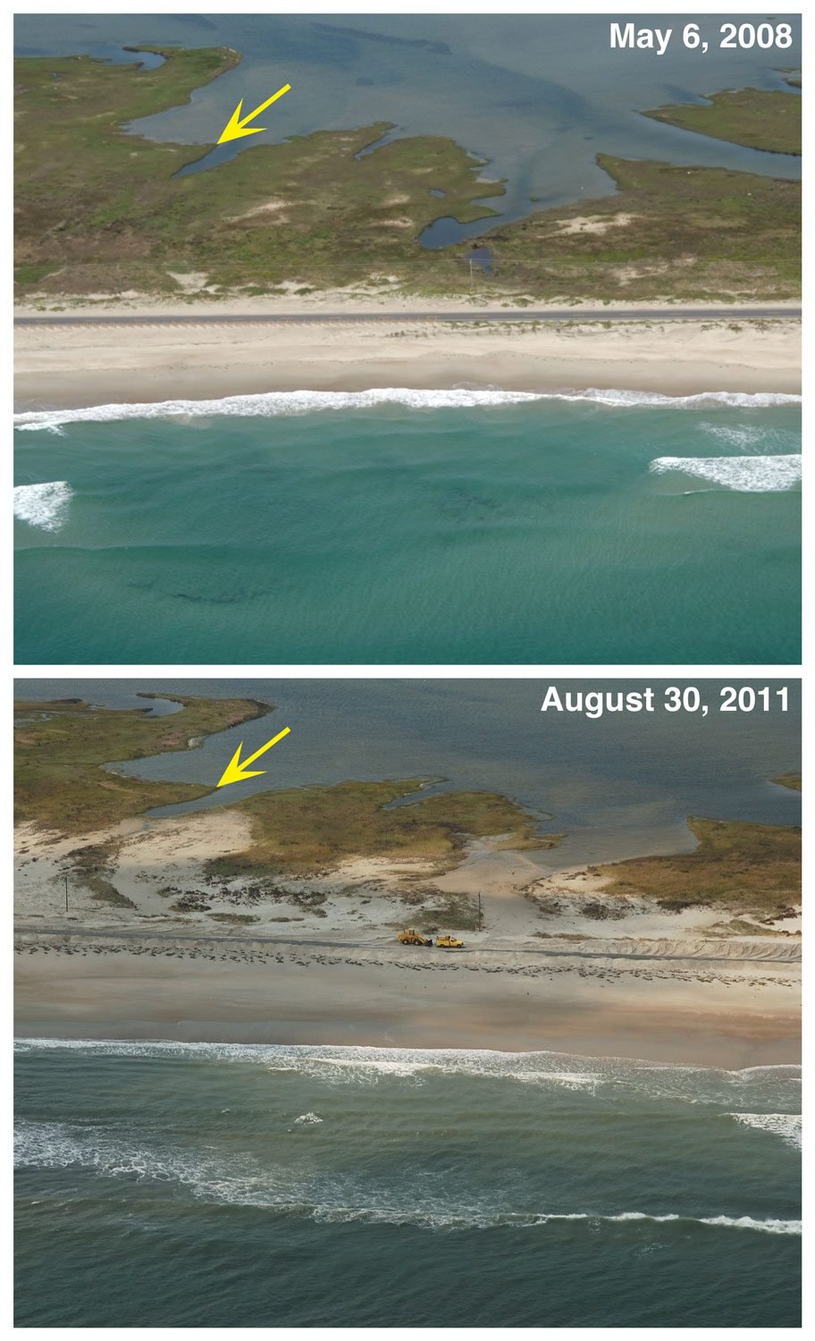
The record, storm by storm
Only storms with a documented Ocracoke-specific effect are listed. Plenty of famous hurricanes — Fran, Bonnie, Floyd, Emily — battered other parts of North Carolina and left this island more or less alone, and it would be dishonest to claim otherwise.
| Storm | Date | What it did here |
|---|---|---|
| The 1846 hurricane | 7 Sept 1846 | Cut Hatteras Inlet, making Ocracoke an island again and nearly doubling its size. Shipping drifted north to the new, deeper inlet over the next fifteen to twenty years and Ocracoke Inlet lost its standing as the state's front door. |
| San Ciriaco | 16–17 Aug 1899 | Seriously damaged the Ocracoke Hotel, which burned the following spring and was never rebuilt. It also changed how islanders built: the "trap floor," a hinged panel that lets floodwater into a house rather than floating it off its foundation, appears to date from after this storm. |
| 1933 | Aug and Sept 1933 | Overwash damaged the trees, figs and grapes in the lighthouse keepers' garden. Two hurricanes struck the coast that year and the record doesn't say which one did it. |
| The Great Atlantic Hurricane | 14 Sept 1944 | The worst storm of the twentieth century here, per the National Park Service. It finished the Navy base, whose buildings were sold off and scattered into houses still standing in the village. A surviving house is called the Hurricane House for the inscription a resident scratched on its wall during the storm, recording six houses demolished. |
| Helene | Sept 1958 | Destroyed 85 percent of the beach improvements — the dune-building and grass-planting program then underway. |
| Donna | Sept 1960 | Destroyed a third of the protective dunes. |
| Gloria | 26–27 Sept 1985 | Landfall on the Outer Banks near Cape Hatteras. The National Hurricane Center later used Gloria as the benchmark for Ocracoke sound-side flooding — the storm everything else was measured against for twenty years. |
| Dennis | 4 Sept 1999 | Stalled offshore for days, then came ashore as a tropical storm. Dropped 19.13 inches of rain on Ocracoke over seven days. Thigh-deep water on the school road; islanders moved through the village by skiff. Little structural damage; four weeks of dead business in the early fall season. |
| Isabel | 18 Sept 2003 | Category 2 landfall. 105 mph gust at Ocracoke (unofficial), waist-high flooding, piers damaged or destroyed, the lighthouse boardwalk wrecked. The famous breach — "Isabel Inlet" — was cut through Hatteras Island, not here, but it severed Ocracoke's northern ferry link until 22 November. |
| Alex | 3 Aug 2004 | The forgotten one. Passed nine nautical miles southeast of Cape Hatteras and pushed roughly six feet of surge into the sound side at Ocracoke Village — the worst there since Gloria, per the National Hurricane Center. Ocracoke took the highest rainfall of the entire storm, 7.55 inches. Hundreds of vehicles and homes flooded. (Local accounts put the high-water mark nearer four feet.) |
| Irene | 27 Aug 2011 | Landfall at Cape Lookout. 69 mph gust and 2.72 inches of rain at Ocracoke; USGS lidar documented beach and dune erosion with sand thrown across NC 12. The catastrophic 10-to-12-foot water and the seven-week road closure were on northern Hatteras Island, not here. |
| Matthew | 8–9 Oct 2016 | 84 mph gust. The tide beat the Alex mark by several inches, flooding homes, businesses and a lot of cars — the island's high-water benchmark until Dorian. It also, indirectly, cost Ocracoke its gas station (below). |
| Florence | 13–14 Sept 2018 | A huge, slow, destructive storm that spared this island: an 80 mph gust, minor flooding in the usual low spots, and no sound-side flooding at all, because of the angle it came in at. |
| Dorian | 6 Sept 2019 | The modern record. See below. |
| Erin | 18–25 Aug 2025 | Never made landfall, never came within 200 miles — and still closed the island for a week. See below. |
Dorian, 6 September 2019
The eye came over Cape Hatteras late that morning. Ocracoke sat on the wrong side of it, and when the wind swung around, the sound came back.
The National Weather Service recorded a four-to-seven-foot storm surge. The Park Service put it at up to seven feet of water above ground level. Local reporting has it at 7.4 feet, arriving around half past seven in the morning. Whatever the exact number, it went through the village faster than anyone could react to: the Coast Guard station at Hatteras logged a rise of 7.16 feet in just over two hours.
What that meant on the ground, from the National Hurricane Center's own report: people trapped in their attics by saltwater flooding and taken out by boat. Others airlifted off the island. Food and water flown in for the people who stayed. NC 12 torn up in two places.
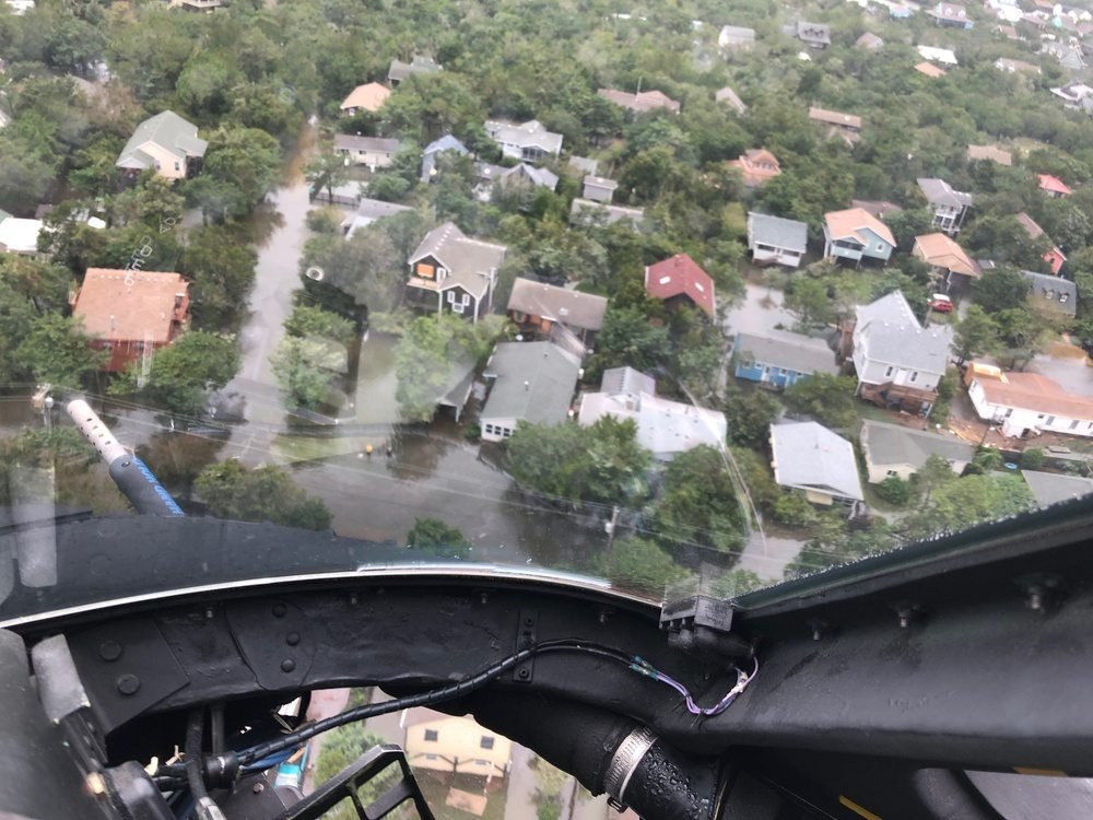
The tally: more than 400 homes and buildings flooded. Over 300 vehicles written off. 88 of the island's 105 businesses significantly damaged. More than a third of the buildings on the island severely damaged. The school flooded and lost a month of classes. At the light station the Park Service measured about three feet of surge at the Store House — enough to shove the building nine feet off its foundation — and found the Oil House submerged. The superintendent's summary: "Nothing escaped the flood from Dorian."
Nobody on Ocracoke was killed. The island stayed closed to visitors until 2 December 2019, close to three months.
You can see the day after from the air on the case file page — NOAA flew the island on 7 September and that frame is Exhibit L.
Erin, August 2025 — the routine case
Dorian is the extreme. Erin is the one that tells you what living here is actually like.
Erin was a Category 2 whose closest approach, on 21 August 2025, was about two hundred miles east of Cape Hatteras. It never made landfall anywhere in the United States. Ocracoke Village took up to a foot of sound-side water and, in the Weather Service's words, "no damage was noted."
And yet: Hyde County ordered visitors off the island from 8pm on Sunday 17 August and residents from 6am on Tuesday the 19th. About 1,206 people left by ferry. NC 12 was closed by ocean overwash and surge from the evening of the 20th until 5pm on Monday the 25th — NCDOT found erosion severe enough to expose the sides of the road. The county's stated reason for evacuating was blunt: with NC 12 impassable, Hyde County EMS would not be able to reach anyone on the island.
A storm two hundred miles away, no damage, and the island was shut for the better part of a week. If you are booking a trip in August or September, that is the risk you are actually taking — not the roof coming off.
Does Dorian hold the record?
Probably. But be careful with anyone who states it flatly, including us.
Ocracoke has never had a long-term sound-side tide gauge. The nearest useful instrument, at the Coast Guard station on Hatteras, was only put in during 2010. So the island's high-water history is a chain of local marks, not measurements: Gloria in 1985, then Alex in 2004 — called the worst since Gloria by the Hurricane Center — then Matthew in 2016, which beat Alex by a few inches, then Dorian, which beat everything.
The widely quoted line that Dorian ran "two feet higher than anything previously recorded" comes from local reporting on the flooding at the light station. We could not find a Weather Service, Hurricane Center, NOAA or USGS document that says it. It is probably right. It is not a measurement.
And before 1944 there is essentially nothing but eyewitnesses. One young visitor who lived through the 1899 hurricane wrote that only six whole houses were left standing and the water stood over the island for three days. That is one person's account of one storm, and no agency ever counted.
What never came back
Here is where the story turns out to be the opposite of what everyone assumes.
Dorian destroyed buildings, not businesses. Five years of retrospectives don't name a single Ocracoke business that closed for good because of the storm. What the island lost was structures — and it rebuilt nearly all of them, some of them only just now.
- Captain Ben's building. The 1970s landmark at Old Beach Road, latterly home to Ocracoke Oyster Company. Flooded by Dorian and torn down by an excavator in about an hour on 27 November 2019. The Oyster Company moved into the old Ocracoke Bar & Grille premises and is open today.
- The old Ocracoke School. Destroyed and demolished; students spent four years in modular buildings. A new pre-K–12 school opened on the same campus in August 2023.
- The Jolly Roger Pub & Marina. Flooded out in September 2019 and dark for nearly seven years, which made it the island's most-assumed-dead business. It reopened in June 2026 in a new two-story building.
- The Island Inn. Not a Dorian loss — two wings were demolished in 2018 — but worth knowing: the 1901 core survives, and it is due to reopen as the Ocracoke Commons Visitor & Cultural Center in fall 2026.
The permanent losses cluster somewhere else entirely.
- Teach's Hole Blackbeard Exhibit and Pyrate Specialty Shoppe — the island's pirate museum and gift shop. Closed in 2020 during the pandemic and never reopened; 935 Irvin Garrish Highway now houses a realty office. There is no Blackbeard museum on Ocracoke. If you have read about one, this was it.
- The Magic Bean Coffee Bazaar on School Road and Kayla's Country Kitchen — both listed as permanently closed by the Ocracoke Observer, both lost in the window between Dorian and the pandemic. Ocracoke took a seven-foot surge and a global shutdown within six months of each other; a year after the storm, only just over half the damaged businesses had reopened.
- Ocracoke Station, the island's only gas station. This is the real "closed after a hurricane and never came back" story, and almost nobody tells it. Hurricane Matthew put seventeen inches of water through it in October 2016. The owners got no insurance payout and no FEMA reimbursement, spent their savings on repairs, and handed the property back in May 2018. Ocracoke has had no conventional filling station since. Fuel is sold at the Anchorage Marina and at Jerniman's Campground — worth knowing before you drive on.
- Ocracoke Child Care, the island's only licensed childcare center, closed in May 2017 — not for lack of demand, it had a waiting list, but because the director couldn't fill two teaching posts on an island with nowhere affordable to live. The building is now six apartments of teacher housing. Not a storm, but the same underlying problem storms make worse.
- Eduardo's Taco Stand, a fifteen-year institution and a fixture of every Ocracoke food list, closed at the end of the 2025 season when Eduardo Chavez went home to Mexico. Nothing to do with weather. Still all over the internet.
Older losses, for completeness:
- The Pamlico Inn — the waterfront hotel with the big dock platform where the island held its Saturday-night square dances. You can see it labeled on the 1927 village map in the case file. The Great Atlantic Hurricane of 1944 destroyed it beyond repair and it was never rebuilt.
- The Ocracoke Hotel — badly damaged by the 1899 hurricane, burned in a kitchen fire the following spring, never rebuilt.
- Coast Guard Station Ocracoke — built 1939–40 on Silver Lake, vacated 1996. Not lost, exactly: the big white building on the harbor is now NCCAT's eastern campus.
If a storm comes while you're here
- Hyde County calls it, not Dare County. Ocracoke is in Hyde. Orders come from the Hyde County Board of Commissioners, and they are separate from anything announced for Hatteras or Nags Head.
- Visitors go first. Typically twenty-four to thirty-six hours before residents. For Dorian: visitors 5am Tuesday, residents 5am Wednesday. For Erin: visitors 8pm Sunday, residents 6am Tuesday.
- There is no bridge. Everyone leaves by ferry — Hatteras, Cedar Island or Swan Quarter. Outbound tolls have been waived during evacuations. All four ways onto the island are here.
- The window closes early. Ferries stop running at around 20 mph of wind. You cannot wait and see.
- NC 12 fails before anything else. The twelve miles between the village and the north-end ferry terminal run across a low, narrow, dune-fronted strip. When it overwashes, the island is cut in half and the ferry becomes unreachable even if it is running — and EMS can't get to you.
- Know where the clinic is. The Ocracoke Health Center runs weekday clinics with a pharmacy on site, and it is the only medical care on the island. The nearest hospital is a ferry and a long drive away — which is the whole reason the county evacuates early.
- Book flexibly in late August and September. That is when the storms cluster, and the island can close to visitors for days over a storm that did nothing.
Named-storm refund: if a named storm is forecast to hit the Outer Banks, Beach4x4, our 4WD rental company in Kill Devil Hills, gives a full refund on multi-day rentals, deposit included. Contact us as soon as possible.
The 2026 season so far: as of this update, no storm has directly hit the North Carolina coast. Three named storms have formed in the Atlantic — Arthur in June, which went into Texas; Bertha in July, which made landfall in Louisiana while its moisture fed a stalled front that flooded parts of inland North Carolina; and Cristobal in August, which fizzled at sea. NOAA forecast a below-normal season. That can change in a week, which is rather the point.
An island that keeps getting rebuilt is worth walking
Blackbeard's Gold: The Crossing starts in the ferry line and works the village on foot — the harbor the Army Corps dug, the houses framed from a hurricane-wrecked Navy base, the trail out to the water Blackbeard died in. Three hours, $29 per team, and the ferry ride is chapter one.
Start the Hunt — $29 per team Pick your crossing$29 per team of up to six, not per person. Your team link arrives by email straight after checkout. Nothing to install.
Common questions
- What was the worst hurricane to hit Ocracoke?
- Dorian, 6 September 2019, for the highest water anyone has seen. The Great Atlantic Hurricane of September 1944 holds the twentieth-century title, per the National Park Service.
- Why does Ocracoke flood from the sound instead of the ocean?
- The slosh effect. Easterly winds pile Pamlico Sound against the mainland; when the wind swings west behind the storm, the water comes back across and floods the sound side one to two hours later — usually after the wind has eased.
- Does the island get evacuated often?
- Yes. Hyde County orders it, visitors leave first, and everyone goes by ferry. In 2025 about 1,206 people were evacuated ahead of a storm that stayed 200 miles offshore and did no damage.
- What closed after Dorian and never reopened?
- Fewer businesses than people think — Dorian took buildings, and most were rebuilt, the Jolly Roger only in June 2026. The permanent losses were the pandemic's (Teach's Hole, the Magic Bean, Kayla's), the 2018 gas station closure after Hurricane Matthew, and Eduardo's Taco Stand retiring after the 2025 season.
- Is there a Blackbeard museum on Ocracoke?
- No. Teach's Hole Blackbeard Exhibit closed in 2020 and never reopened. Several travel sites still list it. The island's museum is the Ocracoke Preservation Society Museum, which is free and open seasonally.
- When is hurricane season?
- 1 June to 30 November, with Ocracoke's damaging storms clustering in late August and September. Book flexibly.
Sources
The slosh effect and sound-side flood timing: National Weather Service, Newport / Morehead City, Eastern North Carolina Coastal Flood Climatology. The villager's quotation and the 1933, 1958 and 1960 damage: National Park Service, Cultural Landscape Report: Ocracoke Light Station, 2016. Sound-side inundation as the primary driver of barrier-island change during Dorian: Sherwood and others, U.S. Geological Survey, 2023. The 1846 inlet cut and the 1899 Ocracoke Hotel, the trap floor, the Hurricane House inscription and 1944 as the century's worst storm: National Park Service Historic Resource Study and the National Register nomination for the Ocracoke Historic District. Dennis rainfall: North Carolina State Climate Office. Isabel: NWS service assessment and the NC State Climate Office. Alex surge and rainfall: National Hurricane Center tropical cyclone report AL012004. Irene: National Hurricane Center report AL092011 and USGS lidar analysis. Matthew: NWS Newport / Morehead City, with the local high-water comparison from the Ocracoke Observer. Florence: Ocracoke Observer. Dorian surge, attic rescues and airlifts: NWS Newport / Morehead City and National Hurricane Center report AL052019; damage totals, the Store House displacement and the reopening date: National Park Service, including the 2022 Ocracoke Light Station rehabilitation environmental assessment; the 7.16-foot two-hour rise at the Hatteras gauge via The Washington Post. Erin: NWS Newport / Morehead City post-storm summary, NCDOT, Hyde County via the Outer Banks Voice, and Coastal Review. Closures and reopenings: the Ocracoke Observer's current what's-open list and its five-year Dorian retrospective, Visit Ocracoke, Island Free Press, The Coastland Times and the Outer Banks Voice on the 2018 gas station closure, and EdNC on the school. The Pamlico Inn and Coast Guard Station Ocracoke: Philip Howard, Village Craftsmen, with the station corroborated by the U.S. Coast Guard Historian's Office. 2026 season status: National Hurricane Center, checked 4 September 2026.